I managed to get a second trip to the Park in 2019. My friend Paul and his son Matthew accompanied me in August to the Upper Works trailhead with a destination of Colden Dam. I was going to be soloing a few peaks while Paul and Matthew did some exploring around Colden and Avalanche Lakes.


We started on a Thursday and arrived at the parking lot around 0930hrs and had no problems finding a spot. As we were gearing up though a whole bunch of canoe and kayak enthusiasts began pulling in.
While the weather was fine, it had rained pretty heavily the night before. The Calamity Brook Trail was quite a soggy mess with the worst of it as we got close to the Flowed Lands. We stopped by the Henderson monument along the way.

For those who don’t know who David Henderson is, he was a founder of the Adirondack Iron Works that operated in this area back in the early/mid 1800’s. The story is that he accidentally shot himself when a pistol in his pack (loaded, primed and cocked apparently) went off and killed him on this spot in 1845. The family had this monument sledded in a winter or two after the incident.
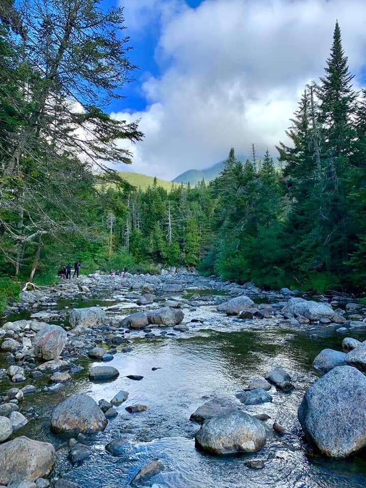
Eventually we made our way to the Colden Dam area and made camp nearby along the scenic headwaters of the Opalescent River. It was getting to be later in the afternoon at this point and I wanted to summit Mt Marshall before dark so I dropped pack, got my hiking pack ready and headed out while Matthew and Paul started setting up their hammocks.

Mt. Colden under the westering sun.

The path up Marshall is an unmarked heard path, the start of which is marked by a cairn along the marked trail between the Flowed Lands and the Dam.

The path was a well worn couple of miles and well marked with cairns where it passed over the brook it followed up the slope. There are the remains of a small plane that crashed in the 1960’s somewhere in the woods on the way up, but I wasn’t sure of its location from this approach (there’s another trail up Marshall behind the Ranger Station on Lake Colden that is apparently closer to the remains) and with darkness approaching I didn’t want to get too far off trail.
The ascent wasn’t very complicated. It was mostly walking up tree roots and the occasional boulder or two with a couple of stretches right up the slabs that are the stream bed. After a couple of large boulders near the summit I was at the mostly wooded peak that is marked by a sign.


I made my way down and back to camp before nightfall, Paul had set up my hammock for me and they were in the process of cooking dinner when I got back so my timing was perfect. After dinner and clean-up we crawled into our hammocks for the night.

I got up around 0630 the following morning, made myself some breakfast and set out along the trail for Redfield and Cliff Mountains. The trail was generally upwards and rocky to the Uphill lean-to site.


There was still a lot of mud to deal with.
The Redfield/Cliff trails are also heard paths. When you get to the Uphill lean-to campsite look for the cairn marking the path, it’s almost immediately across the trail from the tent area. Follow the path for about a quarter mile (maybe a bit less) and you will come to another larger cairn that marks the split for Redfield (to the left) or Cliff (to the Right). I decided to do Redfield first so I went left.
The trail reminded me somewhat of Marshall the day before but a bit steeper and more rocky; lots of tree roots and boulders/slabs along or on a stream. Eventually I made it to yet another mostly wooded summit with some views off of one side.


After some food and water there was nothing to it except back down to the Cliff cairn and back up the trail to Cliff. There was a massive muddy bog at the foot of Cliff that took me a while to navigate, but once I got past that it became the “normal muddy”, and even somewhat dry for a good ways. The climb wasn’t all that bad in terms of grade or effort till I got to the parts that earned Cliff it’s name. A series of..well…cliffs.


On the way up they can appear a little steep and daunting and you do have to be mindful of your approach, but if you stop and analyze the problem for a bit you can find some routes that are not all that bad. There are some “bushwack” walk-arounds but I pulled a couple of easy climbing moves up-and- over most of the steepest parts and didn’t feel all to scared over it.
Eventually you “top out” (or at least think you are topping out…more on that coming up) and start to think you should be looking for a summit marker. Actually you are on one of a series of promontories on the ridgeline that is Cliff Mountain. You wind up descending into a small col then climb up to the…yet again…wooded summit. I found the peak marker but I didn’t go looking around for any trails to a viewpoint. It’s said there are some places to get a view from the summit, but I didn’t see any obvious spots.


I made my way back down to the cairn at the Uphill lean-to and got there around 1430hrs. I considered trying to tack on Gray and Skylight since the trails to their peaks were only a couple of miles up the trail. However, after consulting the map (and remembering taking that trail to Marcy before) I could see that it was a couple of miles up..UP..UP..UP the trail and I would probably be facing a headlamp hike back to camp at the end of it. I decided to leave them for another day and returned to camp right around 1630.
After dinner it started to get a little cooler so we crawled into our hammocks around 1800-1830hrs and I expected to lay awake for a while, or wake up in the early morning hours. Surprisingly I slept through the entire night.
In the morning we ate and packed up for the hike back to Upper Works. After reaching the car we headed for home with the traditional stop for a burger and some beer (for Paul and I at least).
Now for the long slog through winter and spring till I can get back for some more. I’m now officially over the halfway mark to the 46 at 24 peaks climbed.


Leave a comment